yahoo Press
Snow is on the way to Vermont. Here's where and how much to expect
Images

1 / 6

2 / 6
3 / 6

4 / 6

5 / 6

6 / 6
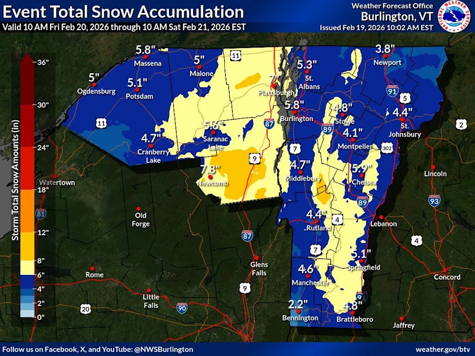
Skiers might be treated to a layer of fresh snow this weekend.

More snow is predicted for Friday, Feb. 20, 2026, with a winter storm watch issued for the southern Greens in Vermont, according to the National Weather Service branch in Burlington, VT.

"A warm front will approach Friday afternoon," the National Weather Service said. "A brief wintry mix or rain in warmer valleys is possible before a quick transition into moderate or heavy snow takes place during the Friday evening commute."

Here's more about what weather is on the way to Vermont.

The timing on the storm couldn't be worse, as it's predicted to hit during Friday's evening commute after being uneventful earlier in the day.

"Snow will be initially wet, and the potential exists for 1 inch per hour snowfall rates Friday evening," according to the National Weather Service's winter storm watch. "Snow will trend lighter and become increasingly dry. Isolated power outages could occur before snow characteristics trend drier."

The winter storm watch has been issued for 10 a.m. Friday until 10 a.m. Saturday along the southern Greens.

"Once we head into Friday night, snowfall rates will generally decline, and then by Saturday morning, snowfall will become very light," according to the National Weather Service's online forecaster's discussion. "When all is said and done, a widespread 3-7" appears likely. Eastern facing foothills of southern Vermont and the Adirondacks appear the most likely to observe amounts approaching 7-9"."

High temperatures on Friday during the day will be in the mid-30s, with lows at night in the low-20s.

There is a "50-percent chance of snow" on Saturday, according to the National Weather Service. It will also be mostly cloudy, with a high near 29, with a "new snow accumulation of less than a half inch possible."

This article originally appeared on wickedlocal.com: More snow coming to Vermont tomorrow. See timing, maps