yahoo Press
'Super El Niño' may be brewing: What it means Minnesota's 2026-27 winter
Images
1 / 17
2 / 17

3 / 17

4 / 17

5 / 17

6 / 17
7 / 17
8 / 17
9 / 17
10 / 17
11 / 17
12 / 17
13 / 17
14 / 17

15 / 17

16 / 17

17 / 17
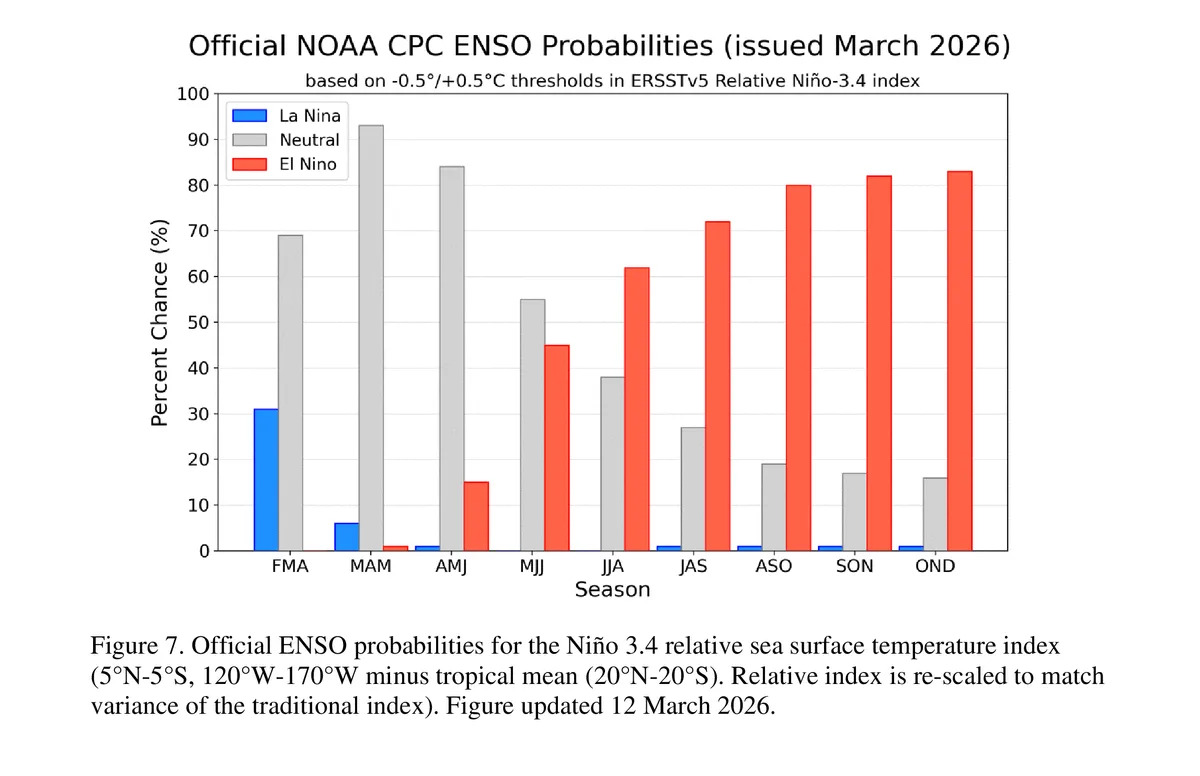
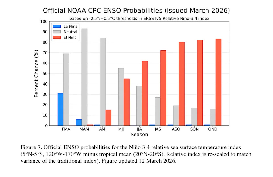
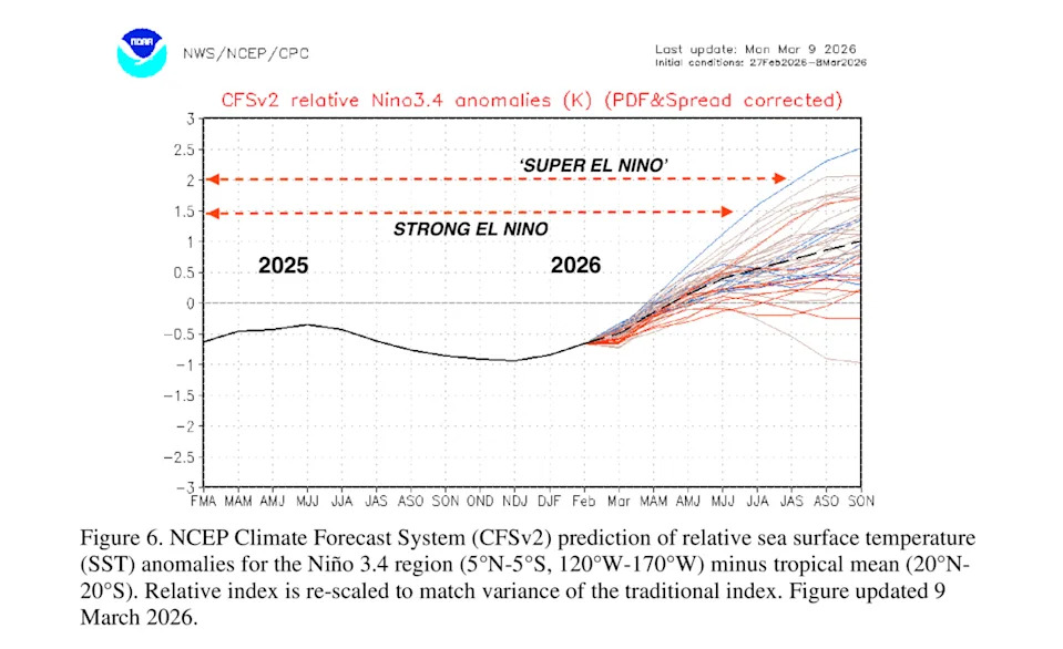
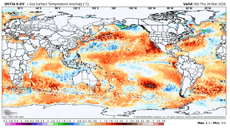
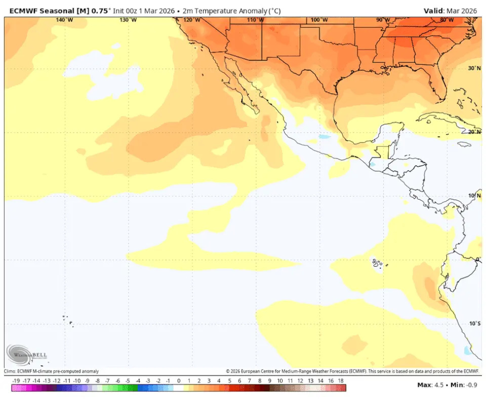
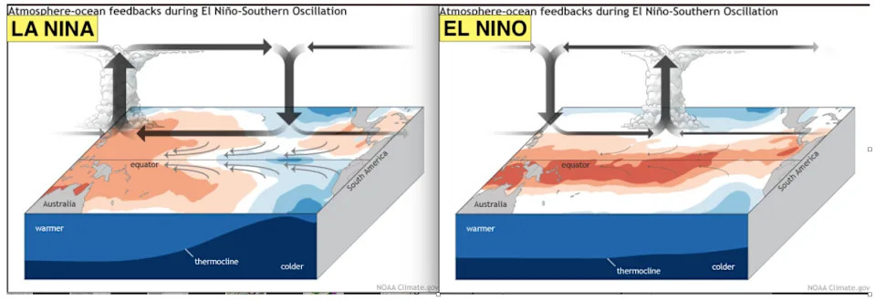
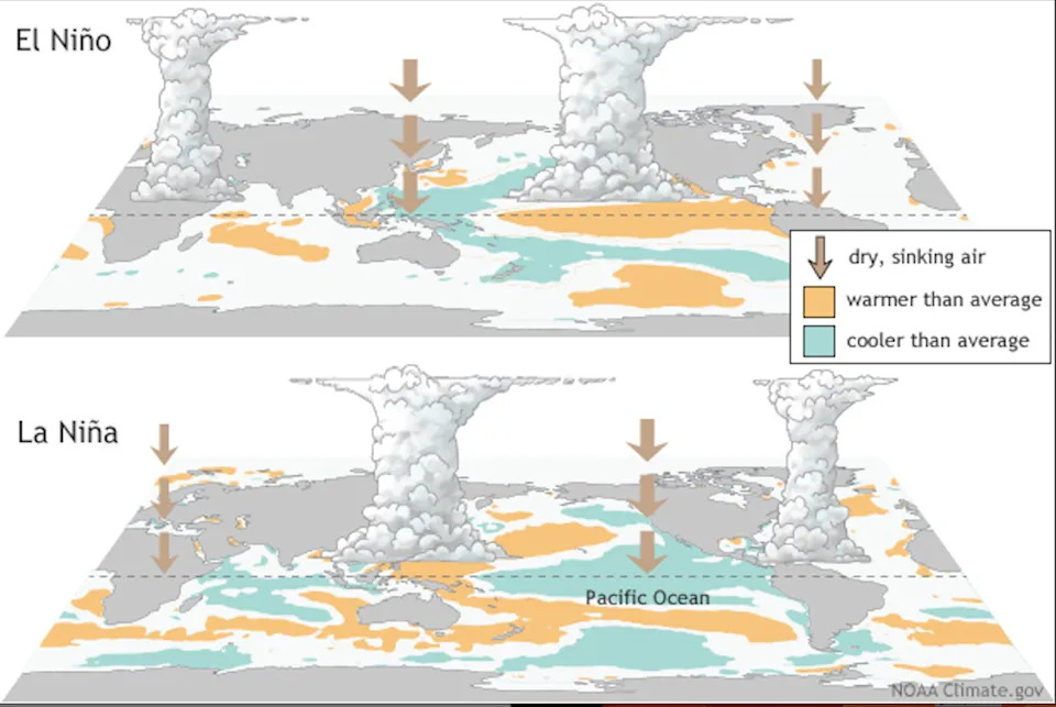
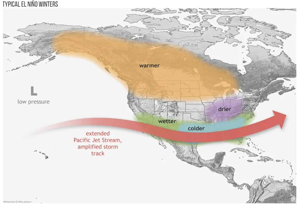
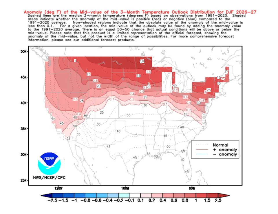
We just finished the winter of 2025–2026, and overall, it was a dud. We had some bouts of cold weather and occasionally some decent snowfall, but it was continuously interrupted by extreme warmth and rainfall events. In the end, it finished warmer than normal, with most of Minnesota seeing below-normal snowfall.

While most of us are fully ready for spring and summer, there are already some strong indicators as to what next winter may bring for our region.

Usually, making any guess, educated or otherwise, about winters that are nine months out is futile… unless you have an El Niño combined with already very warm oceans.

Almost all forecast models agree: we’re leaving La Niña behind, moving into neutral territory, and then likely heading toward El Niño by late summer and fall, possibly another “Super El Niño.” By autumn, the odds of being in El Niño are more than 80 percent, per NOAA’s official forecasts.

The real question is what strength the upcoming El Niño will reach. The oceans are very warm and have been for years, making it easier than ever for El Niño events to become supercharged “Super El Niños.”

The consensus among forecast models is for a moderate to strong El Niño to develop, with some models pushing into “super” territory, which isn’t a technical term, but is often used to describe exceptional El Niño episodes.

You don’t need a trained eye to see lots of orange and red, which far outweigh any tiny pockets of blue.

The seasonal version of the European model, which runs through late fall, shows warmth building in the eastern Pacific. These are averaged monthly surface air temperature anomalies (departure from normal), not sea surface temperatures, but they show essentially the same thing:

While the El Niño and La Niña cycles slosh back and forth three thousand miles south of Minnesota, they have major impacts on our weather—and global weather as a whole. For Minnesota, El Niño in particular has a strong influence in winter.

In La Niña patterns, which we’re just coming out of, colder-than-normal water develops at the surface off the west coast of South America as a result of stronger-than-normal surface (trade) winds. This pushes warm water, heated by the equatorial sun, into the western Pacific. Cold water from the depths of the Pacific is then forced upward to the surface. This upwelling creates the colder-than-normal surface conditions.

When El Niño develops, it’s the result of lighter trade winds, or even a reversal, which allows warm surface water to back up and pool in the central and eastern Pacific.

All of this matters because wherever the warm water is in the tropics, you get large-scale thunderstorm activity. Thunderstorms push vast amounts of air high into the atmosphere, which then descends elsewhere as upper-level “jet stream” winds carry it away.

This completely shifts global weather circulation patterns. La Niña can allow outbreaks of Arctic cold to descend into central North America, whereas in El Niño patterns, that cold is often locked up on the other side of the hemisphere.

Looking at North America, we can see a typical El Niño winter pattern setup:

Much of the north-central U.S., along with Canada and Alaska, tends to experience warmer-than-normal winter conditions with less snowfall. The Pacific jet stream is often extended and more active, bringing storm systems into California and across the southern U.S., producing wetter-than-normal winter patterns. This can be a lifeline for moisture in the arid Southwest and California, replenishing reservoirs, but it can also lead to severe flooding and mudslides.

Already, NOAA’s Climate Prediction Center is forecasting high odds of warmer-than-normal temperatures in Minnesota as a result of this likely El Niño pattern developing from fall into winter.

The stronger the El Niño episode, the higher the odds and magnitude of winter warmth. That’s the main thing we’ll be watching closely in the coming months: just how strong will this El Niño be?

If you’re a winter lover, we may be in for another disappointing season for snow and cold.

This story was originally published by Bring Me The News on Mar 30, 2026, where it first appeared in the MN Weather section. Add Bring Me The News as a Preferred Source by clicking here.