yahoo Press
See Tropical Storm Amanda path tracker, spaghetti models
Images
1 / 20

2 / 20

3 / 20

4 / 20

5 / 20

6 / 20

7 / 20

8 / 20

9 / 20
10 / 20
11 / 20

12 / 20

13 / 20
14 / 20

15 / 20

16 / 20

17 / 20

18 / 20

19 / 20

20 / 20
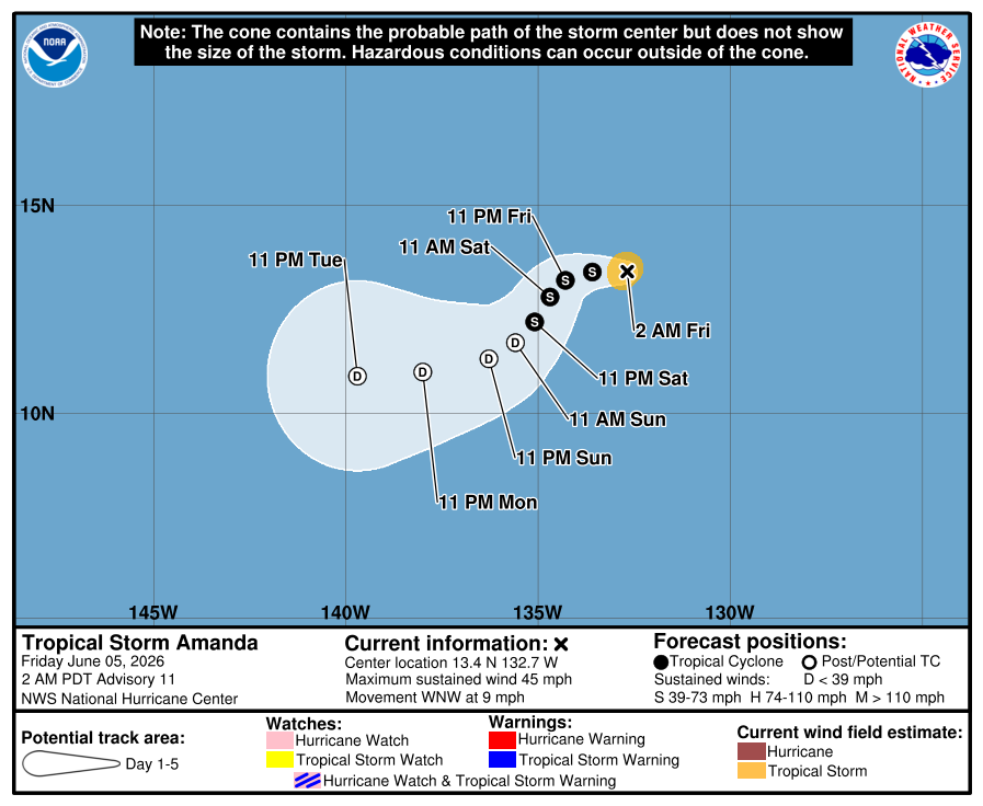
Tropical Storm Amanda formed in the eastern Pacific Ocean on June 3, becoming the first named storm of the 2026 hurricane season.

The National Hurricane Center said in an early morning June 5 advisory Amanda was located about 1,630 miles west-southwest of the southern tip of the Baja California Peninsula with maximum sustained winds near 45 mph.

The storm is moving toward the west-northwest around 9 mph, forecasters said, with a turn toward the west expected later Friday, June 5, followed by a southwestward turn by Saturday.

Little change in strength is expected, according to the NHC, but gradual weakening is expected to begin Friday night and through the weekend, with Amanda forecast to weaken into a remnant low by Sunday.

Amanda does not currently pose any threat to land.

This forecast track shows the most likely path of the center of the storm. It does not illustrate the full width of the storm or its impacts, and the center of the storm is likely to travel outside the cone up to 33% of the time.

Illustrations include an array of forecast tools and models, and not all are created equal. The hurricane center uses only the top four or five highest-performing models to help make its forecasts.

In addition to Amanda, the NHC said it is also keeping tabs on two other systems in the eastern Pacific basin.

Forecasters said in a June 5 advisory a trough of low pressure well offshore of southwestern Mexico is producing a large area of disorganized showers and thunderstorms. Environmental conditions appear conducive for development of this system, with a tropical depression likely forming late this weekend or early next week.

The hurricane center said the system is forecast to move slowly northeastward or northward near the coast of southern Mexico and that interests in the area should monitor the progress of this system. Forecasters give it a 70% chance of tropical development within the next week.

Another trough of low pressure offshore of Central America is also producing disorganized shower and thunderstorm activity, with environmental conditions also appearing conducive for development. A tropical depression could form this weekend or early next week if the system remains offshore, the hurricane center said, with the low expected to move slowly northward toward the coast of Central America.

"Regardless of development, locally heavy rainfall is possible across portions of Nicaragua, El Salvador and Guatemala," forecasters said in the advisory, giving the system a 60% chance of tropical development within the next week.

Gabe Hauari is a national trending news reporter at USA TODAY. You can follow him on X @GabeHauari or email him at Gdhauari@gannett.com.

This article originally appeared on USA TODAY: Where is Tropical Storm Amanda? See tracker, spaghetti models